Faroes
by John Baldwin| Leaders |
| List of members |
| Introduction and aims |
| Summary of fieldwork results |
| Acknowledgements |
Leaders
| John Baldwin | Lothian Region Education Department |
| Annabel Coker | Middlesex Polytechnic |
| Tony Mainwood | Highland Region Education Department |
| Anthony Roberts | St. Luke's Hospital, Bradford |
Members
| Peter Barron | Kings' School, Macciesfield |
| Jonathan Briggs | Bristol University |
| Robert Craig | Southwood Upper School, Corby |
| Susan Fox | Sheffield University |
| Kate Hughes | Colchester County High School |
| Brian Hunter | Liverpool University |
| Roger Mansell | West Midlands Gas Board |
| Teresa Mitchell | Aylesbury High School |
| Mary Morrison | Durham University |
| Kay Mussellwhite< /td> | Durham University |
| Linda Perryman | St. Andrews University |
| Paul Phillips | British Rail |
| Bob Poole | Trent Polytechnic |
| Annabel Riley | Newent Comprehensive School, Gloucester |
| Mark Scruby | York University |
| Colin Wells | Newman College, Preston |
INTRODUCTION AND AIMS
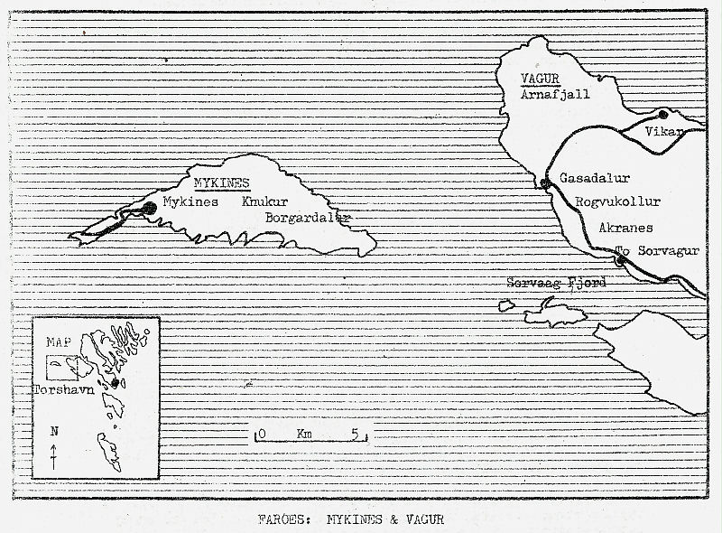
The Faroe Islands lie in the North Atlantic, roughly equidistant from Lewis, Scotland; Norway and Iceland, and were last visited by Brathay in 1970. This year we returned to the westernmost islands - to remote and spectacular Mykines, the Faroes equivalent of St. Kilda, and to tiny Gasadalur on the high and rocky peninsula of north-west Vagur.
The aims of the expedition were:-
a) to explore the spectacular and rugged island groups of Western Faroe -- through mountain walking, rough camping and general self-sufficiency.
b) to assist the local communities where appropriate, with particular community tasks.
c) to pursue a wide -programme of field studies - ornithology, botany/ecology, entomology, settlement studies/ethnology, visitor-pressure survey/trails.
From Brathay to Scrabster is some 437 miles; Faroe almost as far again by sea. Almost all members assembled at Brathay on Sunday 5 July, prior to departure by coach at 06.00 the following morning: It was a fine, sunny morning - Edinburgh, Pitlochry and on to the shore of the Beauly Firth for a mid--afternoon lunch. And so to "Pitgrudie Farm Holidays" -- camping site for the night. The rain began to fall - the last of any consequence for a good two weeks - and delayed even further the fate of feet of Cumberland sausage. We were off by 07.30 next morning, collected Tony in Golspie, and almost witnessed the end of the Expedition on the Ord, just north of Helmsdale. The lorry, to paraphrase Dennis, had no right to be there at all. In Thurso we bought milk and juice for the voyage and orange paint spray for solifluction markers. "Smyril", the passenger flagship of Strandfaraskip Landsins, left Scrabster at midday.
It was a remarkably uneventful voyage, as calm as could be, and ideal for Tony's "Birds at Sea" project - a monitoring project pioneered this year by the NCC/Seabird Group in an effort to help assess the impact of oil developments on seabird populations off the north of Scotland and the Northern Isles. Meantime the North Atlantic mafia was emerging. Was there anyone on board John apparently did not know? There were also some 90 "coffins" on the 'Smyril', quite comfortable little boxes really, into which we climbed to rest for a few hours, until the lighthouse at the south end of Nolsoy forewarned of our imminent arrival.
Torshavn at 00.30 was a lively place - at least around the harbour. With all our kit it was just a short walk to the school where we were to spend what remained of the night. Our building was locked, contrary to Tourist Office information, but a Danish school group in the adjacent building soon had the janitor out of his bed (by now. 01.30). We bought fresh milk on Tuesday morning, consumed cornflakes and cold bacon butties, and at 09.30 the bus arrived.
On a good day it is a spectacular journey over the twisting spine of Streymoy, Faroe's main island, along a road of at least A9 standard. The low, thick cloud - common in the summer time - curled back sufficiently to allow glimpses down Kaldbaksfjørdur and a more prolonged view down Kollafjørdur, across to the massed ridges of Eysturoy and the North Isles. He was a friendly driver who offered a photostop! The little car-ferry 'Sam' left Vestmannahavn at 11.05; we picked up another bus at Oyrargjogv the other side of the Sound; and by noon were in Sørvagur - our base for dispersal to the two expedition locations of Mykines and Gasadalur.
We shall probably never know why the Scrabster Freight Services wrote "destination Midvagur" on the Bill of Loading for the 52 expedition boxes destined for Sørvagur. But the real reason why the boxes had not arrived was that they had lain, apparently ignored, in Strandfaraskip Landsins' warehouses in Torshavn. Peter Weihe is the harbour-master in Sørvagur and a special friend to Brathay expeditions. He had flown home from Denmark that morning to be on hand should there be any problems; by 02.30 he had located the boxes; and in due course extracted a promise from the Company that they would reach our base in the school (kindly made available to us by the town and the headteacher) by 10.00 the following day. We had a most untypical meal that night of flesh bread, meat pasts, fresh fruit, fresh milk - followed by a detailed briefing on the expedition's programme and subdivision into two groups which would interchange between the two locations.
The Shipping Company's lorry arrived ca 13.00 on Wednesday 9 July. A rapid sorting of boxes, the purchase of paraffin, and plan 460 swung into operation! An old jeep took stores and equipment for both Gasadalur and Mykines across to the harbour. Those for Gasadalur were loaded onto a small boat; those for Mykines into the Weihe brothers' store to await the following day's ferry. Nine of us proceeded down the Sørvagsfjørdur to Gasadalur - about 40 minutes sail rather than two hours, from the road-end, over the mountain. It was dry and sunny with only a little wind and the voyage provided a fine prospect of the fantastically-sculpted Drangarnir and Tindholmur and the gently-sloping cap of Gasholmur - all tiny islands and stacks on the southern side of the entrance to the fjord.
We were met at the rough landing (accessible only in the calmest of weathers and only by small boats) by Hjalgrim Petersen, an earlier contact, always helpful and interested in our work. Did anyone count the number of steep, staggered concrete steps 'attached' to the cliff-face up to the valley - 80, 90, 100 or more? It took three awkward carries to get all the equipment up from the rocks.
Gasadalur is a tiny settlement perched 300ft or so above the sea below a group of sharply-defined, rock-strewn mountains forming the cliff-girt promontory that marks the north-western extremity of the island of Vagur. It is a working community with a permanent population of some 19 people. Camp was therefore pitched adjacent to but outside the head dyke, just above the landing place - somewhat sloping and somewhat lumpy, but with shelter from the dyke for cooking and close . to perhaps the most panoramic and exposed washing-up place of any recent expedition, a tiny trickle of water a yard from the unfenced cliff some 170 ft directly down to the sea.
The following day the Mykines group also reached its objective. The 'Sulan' left Sørvagur at 10.00 arriving ca 1 1/2 hours later. The tide rips separating Faroe's western-most island from Vagur were hardly ferocious that day. The landing at Mykines is also difficult of access particularly with heavy weather from the west and south west. Part of the former slipway has eroded away into the sea, and a newer concrete slip with electrically-operated winch and bogey takes cargo and boats - our kit and equipment also - to the upper level, above the cliff. The whole landing complex is built over a large and ever-enlarging cave.
Eleven members comprised the first group to Mykines where again Brathay has a most helpful local contact in Mrs. Davidsen. However, camping on the island is no longer the problem it was in 1970. Mykines barely survives as a settlement. It has but 12 permanent residents, in three families; by and large the infield is no longer cultivated, and very little of the natural meadow grass is cut for hay. An area of infield close by the stream, just above the village, has been earmarked for camping; and here we pitched along with an average of maybe 12 or 14 other tents. The site was almost in the 3-star category plentiful water adjacent, plenty of flat space for tents, a spacious galley area around which drystone dyking skills were practised, a concrete bunker for burning rubbish and an expedition drying green! If Faroe has anything approaching the Lake District in high summer, Mykines must surely be it - the change over 10 years is remarkable.
Partly on account of the greater space available, partly on account of night-petrelling on the Hólmur camp routine on Mykines tended to be carried out by whoever was up/back first. And it was soon the case, by mutual agreement it would seem, that the girls volunteered to take control of all the cooking (porridge apart), in return for release from washing-up and either chores! In Gasadalur, a rota operated, whereby each tent in turn saw a meal through from beginning to end - and was sure to be back to have it ready in time. This provided the strange relief of Bob's inedible custard (an all-purpose sealant and padding), though hardly the highlights of Linda, Mary, Annabel R and Kate's culinary concoctions with pounds of surplus cocoa and oatmeal.
For most of the time we were essentially two self-contained expeditions those first on Mykines coming back to Sørvagur, spending a night there and walking into Gasadalur; those first in Gasadalur sweating up the short sharp zig-zags out of the valley along the flank of the Rógvukollur and dropping equally steeply to Akranes before the road walk to Sørvagur, and on next day to the island.
At changeover time there was considerable pressure on the ferry to Mykines - day trippers, campers, and former islanders returning to fleece their sheep and fleyg their puffins. Queuing was hardly the fashion; both groups therefore found themselves on the second crossings of the day - but no great matter. Even then the water shipped along the sides and stern of the 'Sulan' was more due to its 35 passengers (maximum 20) than to the severity of the sea.
We all made it to Sørvagur by the Thursday - some having left Mykines a little early on account of deteriorating weather and pressure on the ferry. We sorted out kit, bought Faroese Sweaters and fresh bread, made pancakes (at last a use for the dried egg) and prepared for a Friday departure. Peter Weihe had arranged for a local bus, which arrived an hour early - lucky that the equipment was all packed and the school well cleaned even earlier, though John was surprised by Annabel C whilst supping a social farewell coffee with the Weihes! The weather was far from brilliant - wind, low cloud and Faroese mist (more penetrating, if that is possible, than the Scotch variety) - but we visited the Viking farmhouse and byre at Kvivik en route, and were in Tórshavn by lunch time.
Two wet days in Tórshavn before the boat sailed passed a little slowly. Shopping was completed on the Friday afternoon, the museums visited and the sights seen; Grey and damp was the sail down the Nolsoyarfjødur, as we veered away south-east from the South Isles; a few uncomfortable hours about the middle of the crossing led finally to an early morning Scrabster grinting wanly through the sea mist.
All that remained was the long and wearisome road journey south - sea fog in Caithness, soup, coffee and cake on Tony's front lawn (courtesy of Helen and the children; amusement for the neighbours); an overnight camp at Faskally; a further break in Edinburgh the following morning (more coffee and cake, plus pancakes); and finally back to Brathay to unpack, repair and stow away the equipment, fix reunion dates, decide that we would like tee-shirts and agree to let Kate and Annabel R have material for an Expedition Scrapbook before our memories lost their edge.
Both exploration and community assistance were attractive features of the expedition, - such as a three-day mini expedition on Vagur, assistance with sheep round-ups and rock clearing from the landing place at Gasadalur. More details would be given in a longer account, but there is only space here to summarise some of the fieldwork carried out. It reflects the kindliness of both weather and local people, and the vigour and enthusiasm with which members pursued a wide range of tasks.
Twelve working days were spent in each of Mykines and Gasadalur; supplementary observation/recording from Sørvagur and Torshavn also. All field projects were identified well in advance - ornithology, settlement studies/ethnology, -small mammal studies continued the work of previous Brathay Expeditions; all projects were planned to integrate with similar studies by Brathay Expeditions' in Iceland, Orkney, Shetland, the Scottish Highlands and Hebrides. In addition to the projects detailed below, initial geological investigations were made by one member of the expedition, particularly in N W Vagur.
We were particularly fortunate to have the use of Mykines School and Hanna Mikkelsen's new summer house for storing field-study equipment and for the nightly writing-up of results.
| 1. | Ornithology: In addition to 6 1/2 hours of observations maintained at sea as a contribution to the "Birds at Sea" Project (NCC/Seabird Group), fieldwork concentrated on:- | ||||||
| i | Ringing | ||||||
| a) | Petrels and Manx Shearwaters:11 nights mist netting. | ||||||
| 541 | Storm petrels | (inc. 3 British ringed birds and 16 ringed by us on Vagur; no retraps from previous years | |||||
| 573 | Leach's petrels | (inc. 1 British ringed bird and 25 carrying other rings - 21 from 1968, 2 unreadable, 2 from ?1970) | |||||
| 54 | Manx Shearwaters | (no retraps) | |||||
|
Wing lengths, weights, brood patch conditions were recorded for a sample. Numbers caught were smaller than in 1968 (earlier dates, shorter nights and probably smaller teams in 1980). Data for 1970 is not available for checking. |
|||||||
| b) | Other Birds Ringed | ||||||
|
Fulmar - 3, Oystercatcher - 7, Whimbrel - 1, Tystie - 3, Snipe - 3, Bonxie - 1, Arctic skua - 5, Wheatear - 2, Lesser black-back - 14, Greater black-back - 1, Puffin - 2, Starling - 2. (Some of the chicks were reweighed on subsequent occasions). |
|||||||
| ii | Census Work: Counts were made from the shore of Gannets and Guillemots on the Hólmur. Small sections of Kittiwakes near the harbour were counted and sample nest contents recorded. | ||||||
| iii | Arctic skuas: The Mykines colony was mapped roughly, colour phases noted and species chased recorded. | ||||||
| iv | General Observations: Particularly of waders on the pool (Mykines) and of birds seen in the eastern valleys of Mykines. A Red-headed bunting produced the usual derisory comments about escapes. | ||||||
| v | Tystie-chick feeding: Kate Hughes made a special study of feeding frequency and behaviour over a period of 4 days. | ||||||
| 2. | Botany/Ecology | ||||||
| i | Qualitative Botanical Studies | ||||||
| a) | A species list of higher plants compiled for various habitats:- Gasadalur 98 species; Mykines 85 species (of which 18 confined to Ground above 400 m in one/both locations). | ||||||
| b) | Specimens of mosses and lichens collected for future identification, | ||||||
| ii | Quantitative Botanical Studies | ||||||
|
These were made of plant communities associated with different forms of land use; vegetation sampling was carried out by quadrat survey. 82 species were recorded. The areas represented in the survey were:- Gasadalur outfield; old infield; recent intake;) (190 quadrat samples) turf dykes Vikar - outfield; abandoned infield Mykines - outfield; infield; (72 quadrat samples). Also survey of cattle track. |
|||||||
| iii | Solifluction Studies:A study initiated on the N E slopes of Heinanop, north of Gásadalur. | ||||||
| a) | 10 x 10 m. area permanently marked at 515 m on a slope of approximately 25 degree; solifluction terracettes dominated by moss (Rhacomitrium lanuginosum), with stone stripes on gravel areas between. Mapped at 1 m : 2 m. | ||||||
| b) | 1 m. square quadrat, subjectively chosen to include advancing/receding edges of 1 vegetation terracette. Mapped at 10 cm : 2 cm. | ||||||
| 3. | Entomology/Small Mammals Studies | ||||||
| i | Entomology: Extensive collection of Insecta and Arachnida, at both Gásadalur and Mykines. So far, insects from 12 orders identified - Collembola, Ephemeroptera, Dermaptera, Hemidtera, Trichoptera, Lepidoptera, Diptera, Coleoptera. Some of the species recorded are rare in Britain and the Scandinavian mainland. | ||||||
| ii | Small Mammals: 15 Longworth traps set in infield, later in village (Gásadalur); in the Lambi puffinery, later the village (Mykines). In 133 trap nights, no small mammals caught. | ||||||
| 4. | Settlement Studies/Ethnology | ||||||
| Studies aimed at complementing work begun in 1970 - partly new studies; partly repeat studies to identify change and continuity over the 10 year period. All projects listed were carried out in Gásadalur, some also on Mykines. | |||||||
| i | Land Use - Infield | ||||||
| a) | Crop distribution - mapped and coded according to species. | ||||||
| b) | All crop patches other than natural hay measured and sample areas examined to monitor cultivation techniques. | ||||||
| ii | Use of Outfield | ||||||
| a) |
Range of outfield structures and uses mapped and recorded:- sheep shelters; sheep fanks; peat storage structures; areas of peat-cutting; raven hides; horizontal water mills; gates; paths and tracks; boat sheds. |
||||||
| b) | Particular structures/areas recorded in greater detail by measurement, sketch and photograph. | ||||||
| iii | Enclosure Survey:All enclosures in and around the infield and village mapped and coded according to the materials used in their construction - to link where possible with land ownership and age of specific parts of the infield. | ||||||
| iv | Seasonal Round-of-Work:Discussions with local inhabitants produced a summary of the annual work-cycle - agriculture, fishing, fowling, livestock, peat-cutting. | ||||||
| v | Population Survey:Discussion with local inhabitants produced a breakdown of residents by family, age and dwelling (Gásadalur 19; Mykines - 12). House names also collected. | ||||||
| vi | Buildings Survey | ||||||
| a) | All buildings mapped and coded according to their function and the materials used in their construction. | ||||||
| b) | Certain buildings examined in closer detail and constructional detail recorded by measurement, sketch and photograph. | ||||||
| vii | Church-yard Survey: All head-stones in the churchyard recorded - their location and inscriptions. | ||||||
| viii | Survey of Tools, Equipment:A small number of tools recorded (measured etc.) to supplement records from 1970. | ||||||
| ix |
Land Ownership/Rig Names: This study not continued. Representatives of the Matrikulstovan, presently surveying the area, agreed to make their records available in due course. |
||||||
| 5. |
Visitor Survey (Mykines) In view of growing visitor pressure, a questionnaire survey was carried out over two weeks to provide preliminary baseline data for monitoring likely increases and need for provision of specific visitor facilities. |
||||||
| 6. |
Visitor Trails: In view of increased visitor pressure. (Mykines) and the possible effect of the coming tunnel and road (Gásadalur), consideration was given to the identification of trails for each location. |
||||||
We owe a great debt to many individuals and organisations for assistance both before and during the Expedition, most especially to:
Peter Weihe (Sørvagur)
Hjalgrim Petersen (Gásadalur)
Hanna Mikkelsen (Gásadalur)
Mrs. Davidsen (Mykines)
Martin Joensen (Mykines)
Sørvagur School
Mykines School
A Fruutrød School, Torshavn
Matrikulstovan (Torshavn)
Føroya Ferdamannastovan (Torshavn)
Frodskaparsetur Føroyar (Torshavn)
National Zoological Museum (Copenhagen).